Route Guide
Saharan Route Guide (PDF)
Our pre-rally guide from August 2008, with mileage between towns across Algeria and suggestions for overnight stops.
Download route guide PDFThe Road Taken
24 days · ~6,000 miles · 11 countries
Our original GPS tracking data for the Saharan Rally 2009 was lost. The route shown on the map above has been reconstructed from photos, videos and memory, cross-referenced with the team's own pre-rally route guide for the Tunisia and Algeria sections. It's a faithful representation of the roads and tracks we followed, but not a GPS-accurate trace.
We left north-east London in late July 2009 and headed south through France, across into Switzerland and on through Italy to the ferry port at Genoa. From there we crossed to Tunis and started the real work: south through Tunisia, over the border at Talib Larbi into Algeria, and deep into the Sahara on tracks through Gasstoil, Hassi Bel Geubhour, In Amenas and Illizi.
The Saharan loop ran south across the Tassili N'Ajjer plateau, through Djanet and down to Tamanrasset, the furthest south we reached, before climbing back north via In Salah and Ghardaia. We crossed back into Tunisia for a final run through Tozeur, Chebika, Tamerza, Mides, Ksar Gilhane, Matmata and finally Tunis, where we caught the ferry back to Italy.
The drive home took us north through Slovenia, Austria, Germany, the Netherlands and Belgium, back to France and the Channel.
What follows is the original "Sahara Routing Conundrum" write-up from the planning phase, explaining why we ended up approaching the Sahara via Tunisia and Algeria rather than any of the more obvious options. The map below is the one we drew at the time to think the problem through.
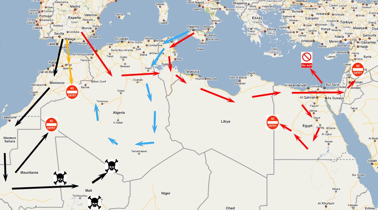
We'd been developing our Saharan Rally route in a bit more detail. When we say more detail, we mean as opposed to not actually considering our route beyond just drawing a line on a map that seemed to go through some interesting places.
The map above probably explains the conundrum. The ideal place to enter North Africa is Morocco: drive down to Spain and ferry over. The ferry crossings are relatively cheap. It would be nice to drive through parts of Morocco and then casually drive into Algeria (the orange route on the map), except there's a slight issue with the Moroccan-Algerian border, which has been closed for almost 15 years. While there have been occasional talks about re-opening parts of it, there's no sign of a grand re-opening any time soon.
The alternative was to drive into Mauritania (the black route on the map), perhaps not the safest country in the region, but safe enough if we were cautious. That would be fine, except the border between Mauritania and Algeria is usually closed or very restricted.
No problem, we thought: we'd go through Mali. We'd always wanted to visit Timbuktu. But there were some serious security concerns going through Mali. We usually take the advice of the UK Foreign & Commonwealth Office in consultation with other sources, as they tend to err on the side of caution. If we followed FCO advice to the letter we'd never travel anywhere. Almost every country comes with the stock line: "there is a general threat from terrorism; attacks could be indiscriminate, including in places frequented by expatriates and foreign travellers."
That said, the FCO's travel advice really is useful and should be taken seriously. A couple of Google searches on Mali and it was clear we'd be risking more than just our petty cash driving through. Having decided that we didn't fancy having our car taken from us by armed bandits, or being shot at by ex-military rebels with AK47s suffering from some kind of power-trip charisma, we ditched the idea of reaching the Sahara via Morocco altogether.
The next option was to enter North Africa via Algeria or Tunisia (the red route on the map). The ferry crossing to Algeria is very expensive, but the one to Tunisia is more reasonable. We thought we were onto a winner: drive through Libya, then Egypt, crossing briefly into Israel, then on via Jordan and into Syria. Enter Syria? No chance. Once you've been through Israel, the Syrian authorities deny you entry. If you've been to Israel, ever, you're not welcome in Syria.
The alternative to exiting Egypt via Israel and then on to Syria was to try to ferry out of Egypt to Turkey or Greece. It sounded like an expensive idea, but worth investigating. It didn't take long to find out there were no active ferry routes out of Egypt on the Mediterranean side, and there hadn't been for 15 years according to the RAC travel advice service when we called them. Some Google searches did turn up limited and very unreliable ferry services. Apparently there had been some between Egypt and Greece during the last Olympics but they'd been discontinued soon after. We also considered trying to get the car onto a cargo ship out of Egypt, but the risk of being stuck for weeks arranging it was too high.
Our last option was to return to Libya from Egypt and then ferry out of North Africa from Tunisia. The problem was that no multi-entry visa for Libya exists. Upon further digging and speaking to a few Libyan travel agents, we found out a multi-entry visa is technically possible, but only if you've already been to Libya on a single-entry visa. Since we'd never been, that was out of the question. You can get a new visa for Libya while in Egypt, but there's a good chance you'd be waiting weeks for it to be issued.
So after many hours of research we landed on the only route that was actually viable: ferry from Italy to Tunisia, loop deep into the Algerian Sahara, and ferry back from Tunisia. Ferry crossings to Tunisia are relatively inexpensive, and while there are a few danger spots (Algiers and the surrounding region, and the areas bordering Morocco), most can be avoided, and we planned to avoid all of them.
Our final Saharan route saw us spending just over 3,000 miles in the Sahara desert, looping around in Algeria before returning to Tunisia to ferry back to Italy. Algeria, being the largest country in North Africa, has a varied Saharan terrain on offer, and we were getting very excited about taking it on there.
Route Guide
Our pre-rally guide from August 2008, with mileage between towns across Algeria and suggestions for overnight stops.
Download route guide PDF